Longitudinal cracking of a thick topsoil layer on an embankment dam did not self heal, leading to a translational slip
Publish date
02 September 2025
Case ID#
3269
Title
Longitudinal cracking of a thick topsoil layer on an embankment dam did not self heal, leading to a translational slip
Nation
England
Regulator reference no.
539
Legal status
Statutory
Reservoir type
Non-impounding
Reservoir capacity
10 - 24,999m3
Year of construction
1990 - 2009
Main construction type
Earth fill embankment
Dam height
5 - 9.99 metres
Dam flood category
B
Hazard class
High-risk reservoir
Reservoir use
- Water supply
Owner type
Limited company
Date & Time of incident
06 January 2025 - 12:00
Date incident closed
06 January 2025
Observations that caused the incident to be declared
- Instability or failure of water retaining pipes, valves or similar structures
- Slope or face deformation (slippage, cracking, slumps, mounds, depressions)
Describe the incident
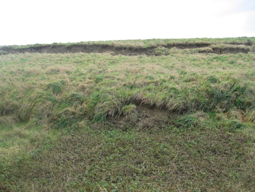
On the morning of 6th January estate personnel observed that a slip had occurred on the downstream face of the northern embankment of the reservoir. The area was visually inspected; it was observed that there was no clear ongoing movement or discharge of water, but that the toe area around the entire embankment perimeter was very wet (this is consistant with very heavy rainfall of approximately 60mm on the evening of 5th January). The Undertaker's representative was contacted, and he then advised the Supervising Engineer. The Supervising Engineer visited the site on 6th January and discussed his findings with the Undertaker and QCE. A summary of the site visit notes is below: Reservoir level -10.8 on the ramp (I estimate around 2.5m below TWL) The area of the slip on the downstream face is approx. 80m length at the western end of the northern bank. No signs of movement or of extensive longitudinal cracking on the remaining perimeter. At the area of the slip the upstream face and crest appear undisturbed, slip extends from approx. downstream edge of the crest to approx. 2m upslope from the toe. No signs of increased seepage or other distress and the rotational component of the movement appears pretty small so appears to be a relatively shallow slip perhaps 1 to 2m deep in places. Note this would be consistent with this being entirely within the non-structural additional topsoil thickness noted in the annex to the CoEEoW. Crest width in this location was measured at 9m this is significantly wider than the nominal 4m shown in the record drawings in the annex to the CoEEoW so suggests the topsoil wedge could be up to 2m thick. During construction it is understood that there was a significant surplus volume of topsoil / subsoil material from the reservoir footprint that was unsuitable for use as structural embankment fill. According to the Annex to the Certificate of Efficient Execution of Works, this material was placed on the downstream shoulder of the embankment; investigations following the incident indicate that the thickness of material placed was approximately 1.5m to 2m. The last S10 report (2018) notes that "The crest carries a significant thickness of topsoil which has desiccated during the recent and prolonged wet weather. I consider that these cracks will self-heal when the autumn/winter rains come and moisture contents rise. If the cracks do not "heal" then I recommend that the cracks be filled with a dry sand/topsoil/grass seed mix poured into the fissures." The Supervising Engineer has subsequently observed desiccation cracking on the crest and downstream face; however, this has typically self-healed in the autumn/winter. It appears that there was a longitudinal desiccation crack along the downstream face of the northern embankment, just below the crest, that did not self-heal over the autumn of 2024. During the exceptionally heavy rainfall of the evening of 5th January 2025, this crack filled with water, resulting in lubrication of the interface between the non-structural topsoil and the clay fill beneath. This caused a translational failure of the ~1.5m to 2m thick topsoil wedge. A section of embankment approximately 80m in length was affected, and the topsoil wedge moved downslope by approximately 2m.
Supporting photos
Natural processes which initiated or contributed to the incident
What were the main contributing factors to the incident occurring?
Dam factors
- Instability
External factors
Shortcomings
- Construction shortcoming
What was the root cause of the incident?
During construction it is understood that there was a significant surplus volume of topsoil / subsoil material from the reservoir footprint that was unsuitable for use as structural embankment fill. According to the Annex to the Certificate of Efficient Execution of Works, this material was placed on the downstream shoulder of the embankment; investigations following the incident indicate that the thickness of material placed was approximately 1.5m to 2m. The last S10 report (2018) notes that "The crest carries a significant thickness of topsoil which has desiccated during the recent and prolonged wet weather. I consider that these cracks will self-heal when the autumn/winter rains come and moisture contents rise. If the cracks do not "heal" then I recommend that the cracks be filled with a dry sand/topsoil/grass seed mix poured into the fissures." The Supervising Engineer has subsequently observed desiccation cracking on the crest and downstream face; however, this has typically self-healed in the autumn/winter. It appears that there was a longitudinal desiccation crack along the downstream face of the northern embankment, just below the crest, that did not self-heal over the autumn of 2024. During the exceptionally heavy rainfall of the evening of 5th January 2025, this crack filled with water, resulting in lubrication of the interface between the non-structural topsoil and the clay fill beneath. This caused a translational failure of the ~1.5m to 2m thick topsoil wedge. A section of embankment approximately 80m in length was affected, and the topsoil wedge moved downslope by approximately 2m.
Impacts on the reservoir
- Mass movement
Supporting photos
Describe any human factors which influenced the incident
Describe any instrumentation at the reservoir and how this was used in warning of the incident or providing monitoring during the incident
Not applicable
Was instrumentation effective leading up to and during the incident?
Not Applicable
Describe any assistance by external parties and impacts on the downstream population
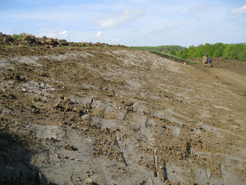
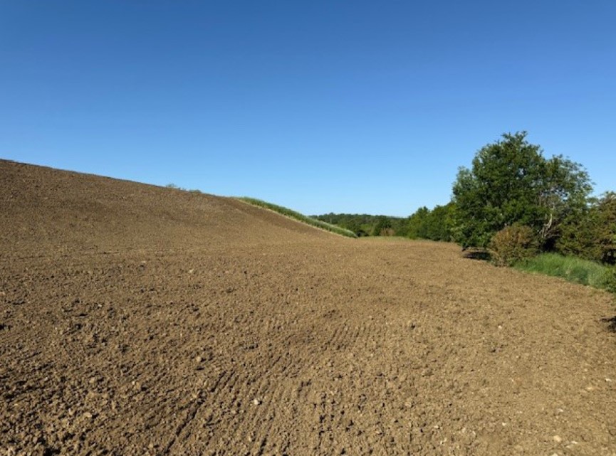
All slipped material was removed and the downstream face reinstated by placing 200mm depth of topsoil. Surplus material placed in a low berm at the toe of the embankment, with cross-fall away from the embankment to provide surface water drainage and prevent ponding at the embankment toe. The reduction in topsoil thickness at the location of the slip reduces the likelihood of a similar slip reoccurring in this location. It is noted that non-structural topsoil / subsoil thickness of 1.5m to 2m remain around the rest of the reservoir embankments; as there has been no mass movement in these areas no works have been undertaken. Surveillance to be implemented by the Undertaker and Supervising Engineer to monitor for persistent longitudinal dessication cracks that do not self-heal in Autumn.
Summary of studies or investigations undertaken
Supporting photos
Lesson 1
- General design and construction
A thick layer of topsoil on the embankment dam is susceptible to dessication cracking in the summer months. The slip that occurred demonstrates that any persistent longitudinal cracks that do not self-heal provide a pathway for surface run-off and so present a risk of mass movement of the topsoil in the event of exceptionally heavy rainfall.
Lesson 2
- Records and studies
A good lesson from this is that the level of detail in the CoEEoW meant that the root cause of this incident could be established quickly and acted upon
Lesson 3
- Regulatory
Identifying particular features at dams (such as the thick topsoil here) is important to note to apply additional operational activities (eg surveillance, monitoring) to ensure specific risks are managed