Third party excavation at toe of FSR embankment threatened dam stability
Publish date
19 November 2026
Case ID#
3371
Title
Third party excavation at toe of FSR embankment threatened dam stability
Nation
England
Regulator reference no.
553
Legal status
Statutory
Reservoir type
Impounding
Reservoir capacity
10M+ m3
Year of construction
< 1800
Main construction type
Earth fill embankment
Dam height
2 - 4.99 metres
Dam flood category
A
Hazard class
High-risk reservoir
Reservoir use
- Flood risk management
Owner type
Public body
Date & Time of incident
09 May 2026 - 12:00
Date incident closed
05 July 2027
Observations that caused the incident to be declared
- Other (including pollution and unplanned scour release)
Describe the incident
A deep and vertical sided, unsupported excavation was created by a group of historical enthusiasts without permission or method statements. The excavation was completed within a few hours, and was immediately at the downstream toe of the embankment dam. The reason for the excavation was to retrieve a WW2 armoured vehicle, of which many are buried in the area. A similar event had occurred in 2021, where permission was granted for a qualified construction company to extract one of these vehicles. For this event, the group thought they had received permission to conduct the retrieval, and a flood risk activity permit was not required if the works had occurred more than 16m from the flood defence. This did not happen, and the works were directly adjacent to the reservoir embankment.
The incident was noted when a staff member of the undertaker recognised the location through the social media account of the group. The undertaker visited site to check the works, and found the significant excavation with no evidence of adequate health and safety considerations or method statements. The undertaker contacted the supervising engineer, who happened to be on site elsewhere with an ARPE. They reviewed the footage and requested the works be stopped immediately.
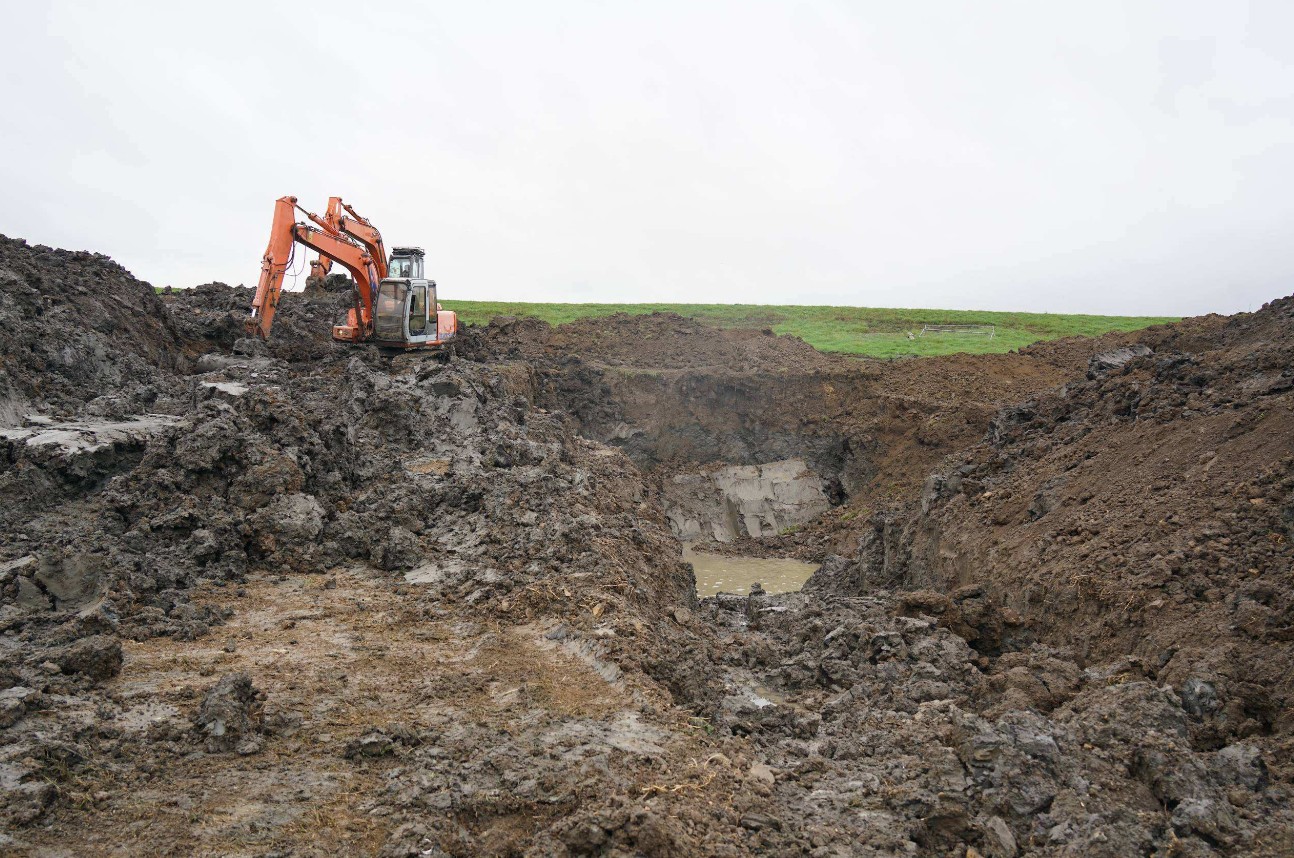
The excavation consisted of an open pit with unsupported, vertical sides, including one access ramp. The pit was estimated to be approximately 20 metres wide (parallel to the line of the reservoir embankment) and 30 metres long (perpendicular to the embankment) and up to 8 metres deep with water in the invert to a depth of approximately 3 - 4 metres. Spoil excavated from the pit has been placed around the perimeter of the hole, in places, right up against the vertical exposed face of the excavation, to a height of up to 3 metres.
The exposed virgin material in the excavated sides of the pit exhibited severe signs of weathering, desiccation and collapse.
The undertaker ensured the flood storage area remained empty though usage of the lower outlet and upper level penstock, until a suitable remediation was complete.
Supporting photos
Natural processes which initiated or contributed to the incident
- None
What were the main contributing factors to the incident occurring?
Dam factors
External factors
- Other external factors (describe below)
Shortcomings
- Process or procedural shortcoming
What was the root cause of the incident?
A third party excavated within close proximity to the toe of the downstream face of the embankment dam. They assumed they had permission for the excavations, but excavated much closer to the embankment then was accepted on a previous activity in 2021. This caused concerns and potential stability issues with the embankment. There was no surveillance or due diligence of the excavation methods (no method statement provided) and the undertaker was not aware of the proximity or nature of the works. There was no Flood Risk Activity Permit (FRAP) for the works, which there should have been as this was within 16m of a flood defence.
Impacts on the reservoir
- None - near miss
Supporting photos
Describe any human factors which influenced the incident
The undertaker stopped the works being conducted by the third party as soon as they became aware that they had dug much closer to the bank than they had originally arranged. The reservoir Supervising Engineer was contacted immediately, who in turn contacted an ARPE. The ARPE confirmed all works need to stop immediately. The main contributing factor is that this dam embankment is 20km long, with multiple landowners who regularly carry out works near the embankment. In this instance the undertakers were assured that the works would not effect the embankment, however no suitable surveillance or due diligence was carried out before work commenced.
Describe any instrumentation at the reservoir and how this was used in warning of the incident or providing monitoring during the incident
Not applicable - instrumentation would not have identified or monitored this incident
Was instrumentation effective leading up to and during the incident?
Not Applicable
Describe any assistance by external parties and impacts on the downstream population
There was minor impact on the local population. The local fishing club's lake was immediately adjacent to the hole that had been dug and there were concerns the remediation works would effect the pond. Access to the pond and a public footpath were restricted.
Summary of studies or investigations undertaken
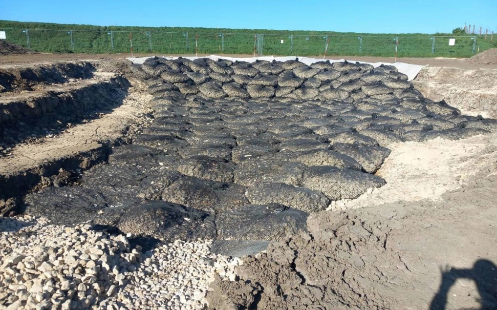
Due to the waterlogged excavation and wet excavated material. The reinstatement consistent of:
- Removal of spoil on top of the excavation sides.
- Battering of the slopes to stabilise the excavation (not the reservoir slope).
- Dewatering the excavation.
- Installation of geotextile membrane on the reservoir excavation face.
- Installation of Salix Aqua Rock Bags for access and to support the excavated reservoir face.
- With the reservoir slope supported. The remaining excavation was then infilled with the excavated material and tracked in with the machine in layers.
Supporting photos
Lesson 1
- Regulatory
Excavations within 16m of the toe of a flood risk embankment are regulated not 8m as per other activities (works adjacent to main river). Therefore a flood risk activity permit should have been applied for the excavation and this would have reduced the risk of unsupervised works adjacent to the flood storage reservoir.
Lesson 2
- Regulatory
It can be difficult to know that an embankment is a statutory reservoir embankment when remote from a river - in this case, the washland reservoir embankment is more than 20km long. Lessons should be learnt to improve awareness of these structures.
Lesson 3
- Emergency response
Response time to infill the excavation is critical, and remediation plans should consider the weather conditions. In this case, Autumn rainfall events filled the excavation and made the excavated material too wet for reuse to support the slope next to to the reservoir embankment. A new solution was then required using imported material.